Forest Intervention Priority Dashboard – Luxembourg
Environmental analytics and decision-support dashboard integrating habitat inventory data, ecological assessments, Sentinel-2 NDVI observations, GIS analysis, Python and Power BI.
This project uses official Luxembourg habitat datasets and satellite-derived environmental indicators for analytical and portfolio demonstration purposes.
Overview
This project was developed as a data analytics and decision-support case study for environmental management and biodiversity conservation in Luxembourg. The objective is to identify habitats that may require priority conservation attention by combining habitat inventory data, habitat quality assessments, ecological value indicators and remote sensing observations.
Data Sources
- Habitat Inventory (WBK)
- Protected Areas (ZPIN)
- Administrative Triages
- Ecological Sectors
- Sentinel-2 NDVI observations, 2019–2025
Methodology
Habitat Profiling
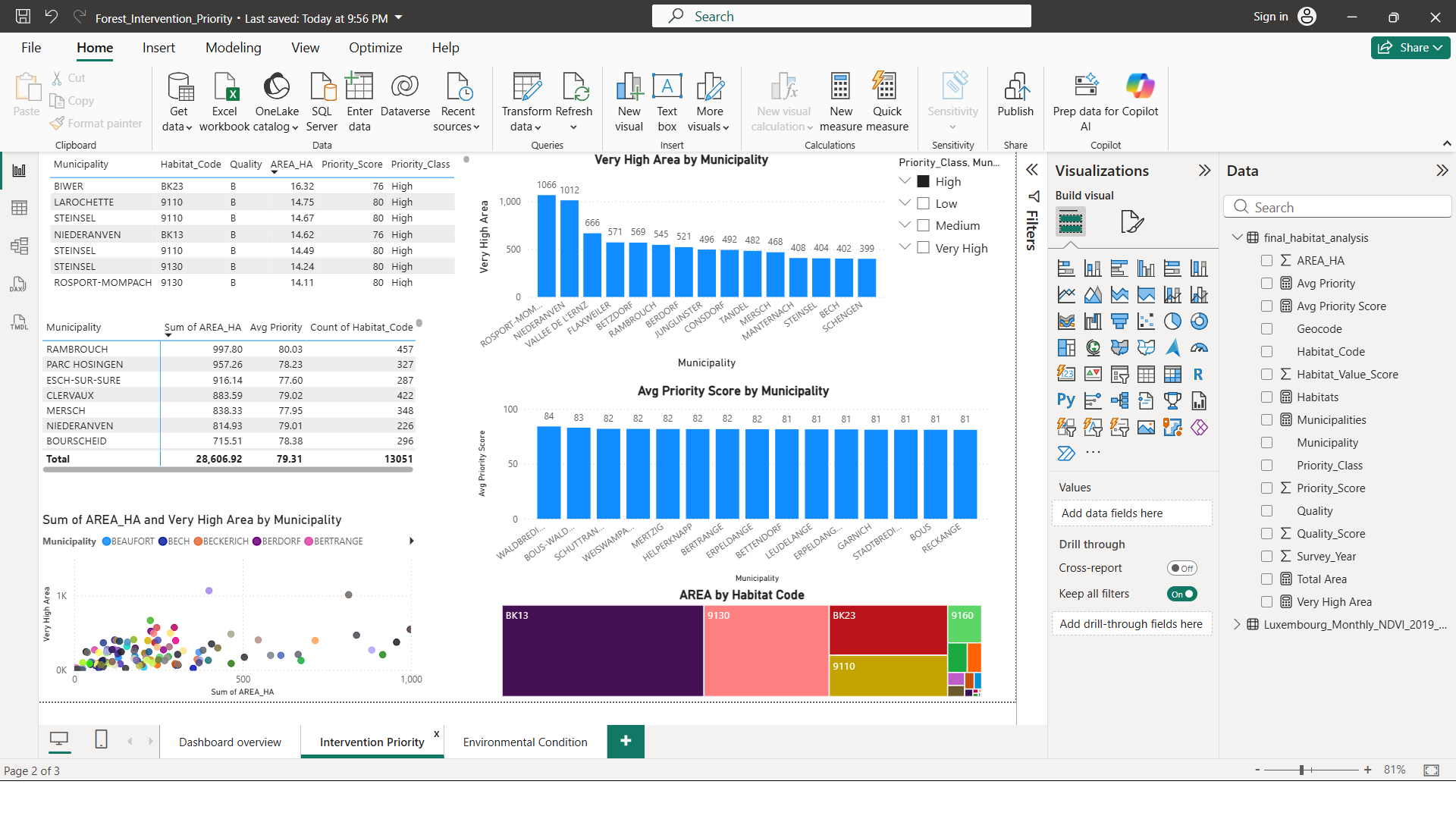
Habitat inventory data was analysed to identify habitat distribution, area, quality and municipality-level patterns.
Priority Index
A habitat intervention priority score was developed using habitat quality, ecological value and habitat area.
NDVI Monitoring
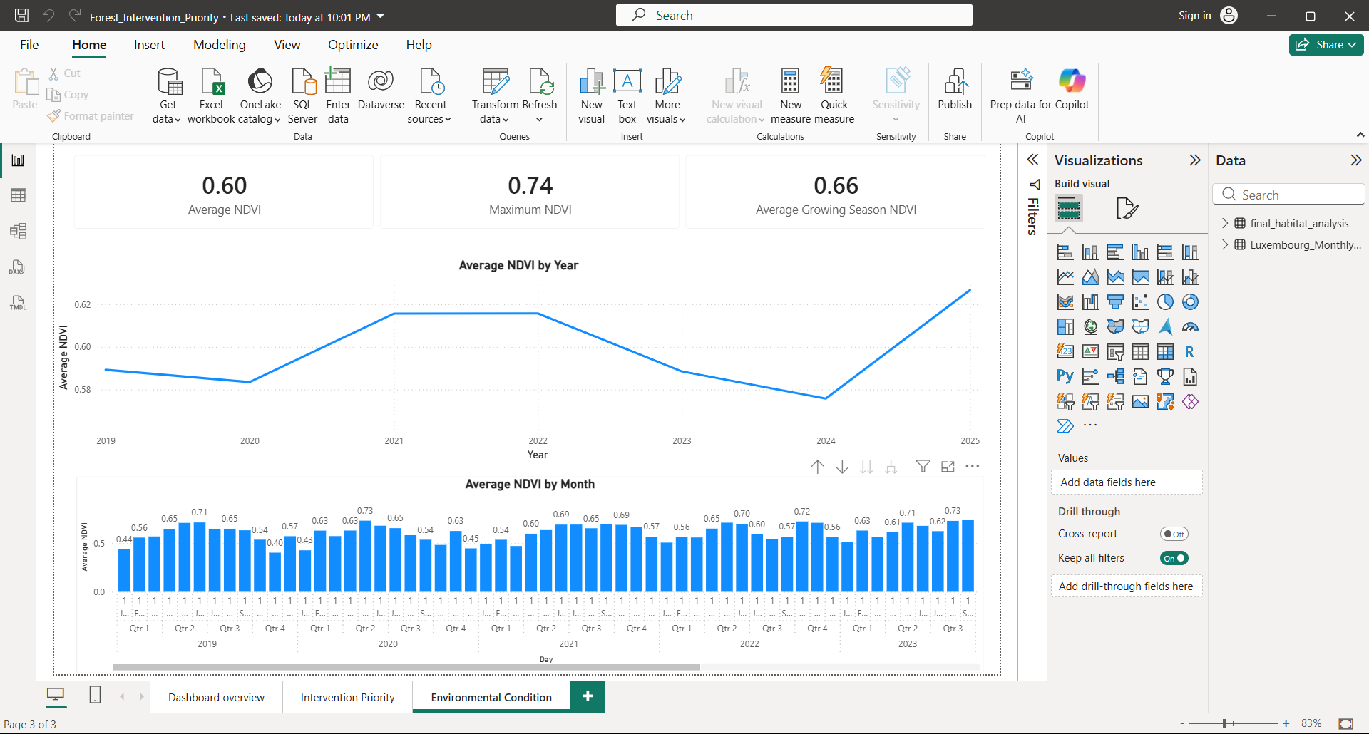
Sentinel-2 NDVI time-series analysis was used to assess vegetation dynamics and environmental condition from 2019 to 2025.
Key Findings
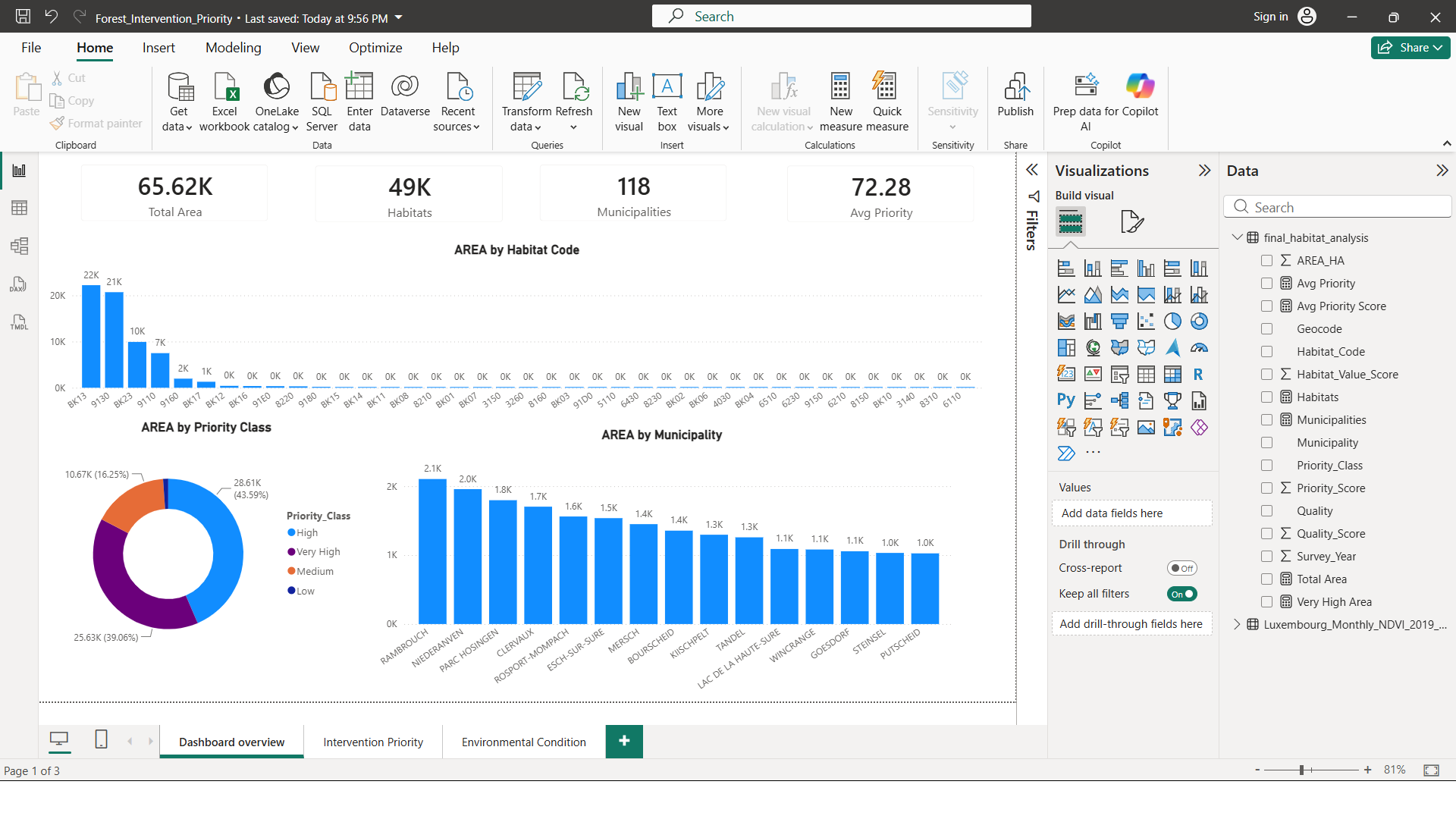
- 48,721 habitat polygons analysed.
- 39 habitat types identified.
- More than 65,000 hectares of mapped habitat area.
- Habitat quality is dominated by class B habitats.
- High and Very High priority habitats represent more than 54,000 hectares.
- Vegetation conditions remained relatively stable between 2019 and 2025.
Technology Stack
Dashboard Screenshots
The dashboard provides a structured view of habitat distribution, intervention priority and environmental condition indicators for conservation planning in Luxembourg.
Executive Summary
This analysis examined 48,721 habitat polygons covering approximately 65,620 hectares across Luxembourg. The results show that habitat area is highly concentrated within a small number of habitat types. Forest habitats BK13, 9130, BK23, 9110 and 9160 account for a substantial share of the total mapped habitat area, indicating that conservation outcomes are strongly influenced by the management of these dominant habitat groups.
A habitat intervention priority index was developed by combining habitat quality, ecological value and habitat area. Approximately 44% of the total habitat area falls within the High priority category and 39% within the Very High priority category. Together, these categories represent more than 54,000 hectares of habitat with elevated conservation importance.
Remote sensing analysis based on Sentinel-2 NDVI data from 2019 to 2025 indicates relatively stable vegetation conditions at the national scale, with average annual NDVI values remaining within a narrow range between approximately 0.58 and 0.63.
Future Development
- Habitat-level NDVI integration
- Spatial joins with protected areas
- Triage-level analysis
- Ecological sector analysis
- Predictive ecological risk modelling
GitHub Repository
The repository includes Python notebooks, input data structure, analytical outputs, dashboard screenshots, documentation and requirements.
View Project on GitHub